Mt Whitney Hike (over 6400 ft elevation gain and 22 miles, altitude of 14505 ft)
 |
| Promila's sandwiches on the way |
I have been looking forward to this hike for a long time. I had heard so many stories about Mt Whitney since I have been hiking for last two years; most of them were quite discouraging and daunting which added to intrigue of the challenge. First time I heard it from a person who had been hiking for last 12 years, hiked Half Dome (at that time I had not even hiked Half Dome); who said that he could not complete it as he was exhausted and had a big headache. Another person, mentioned that he started vomiting at the start of switchbacks (there are 97 switchbacks which comes after half of the hike is completed). Almost everybody mentioned that altitude would gets you, i.e. hike starts from the altitude where Half Dome ends and then goes on for another 6100 feet. I knew this hike needed both mental and physical strength. Since it was going to be a long hike, you need to carry more water and weight, means around 20 lb of backpack lugging around for 12-18 hrs; not just legs needed to be strong, your core needs to be strong. Since I was hiking and running for most part of the year, I did not do anything special. I was looking forward to this challenge and was more curious to see how I reacted to altitude.
Big thanks to Chetan who had done this hike few years back; and like for so many hikes earlier, he organized this hike too. He booked for permits in February; knew that best time to do the hike was in late summer when we would not need ice axes or crampons. He booked the camp site, rental car; constantly told us that this was the hardest hike of all. He broke the hike in segments, what to eat, when to eat, and when to turn back if we were not feeling well. The youngest guy in our group of four was the most informed and leading the hike. Though when he applied for permit, he did not anticipate that his son, who was born just few days after he applied for permit, would hardly give him time to prepare for the hike.
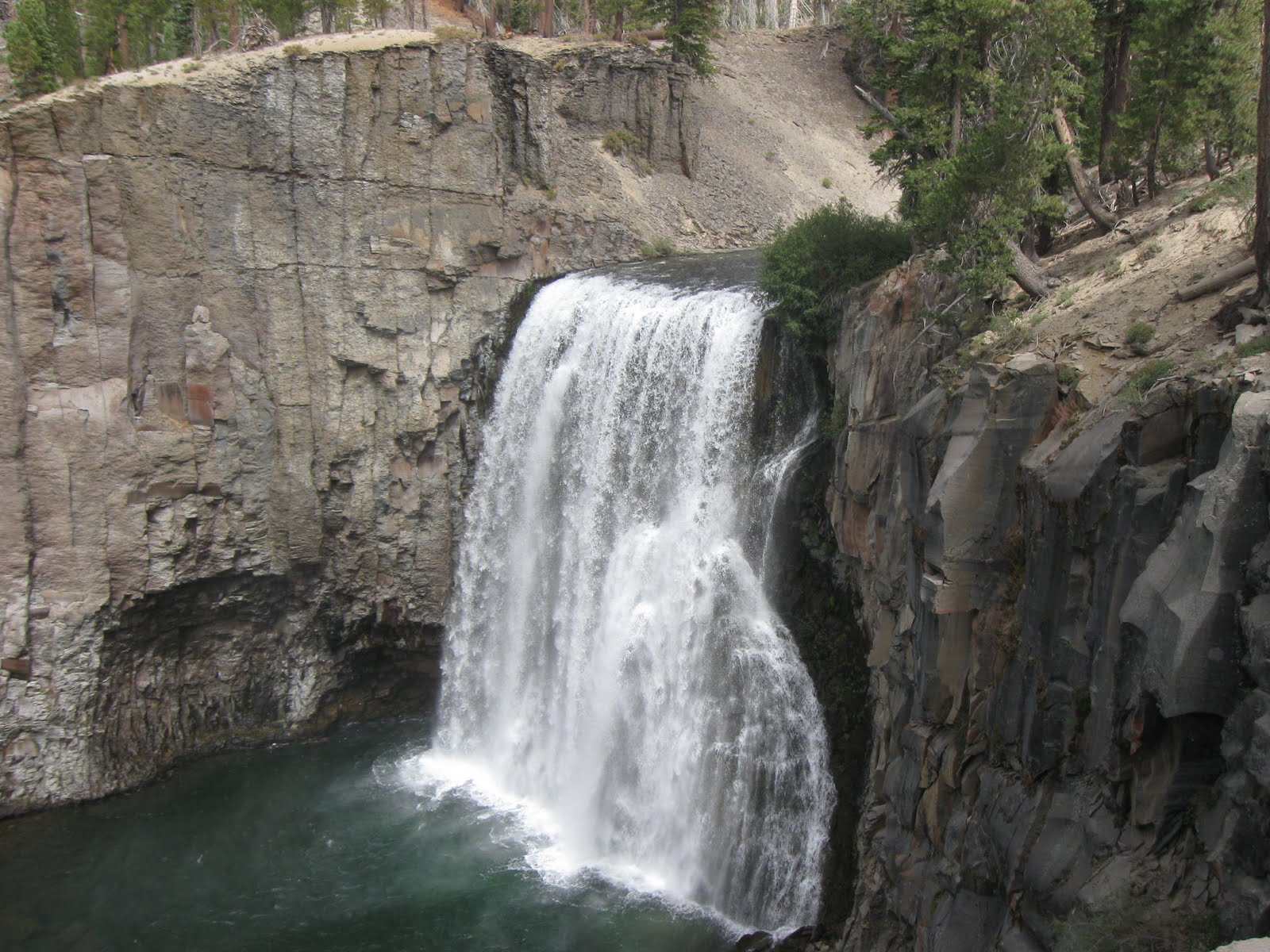
 |
| Rainbow Falls |
 |
| Devils Postpile |
Day 1 – (Saturday - August 28) - A day before on Friday, we picked the rental car. We did a mock packing on that day to ensure that all of our stuff could fit in the trunk (4 sleeping bags, 4 backpacks, 1 car camping tent and 4 small suite cases; along with hiking sticks and hiking shoes). We had to keep two of the sleeping bags in backseat. It worked out fine, as they proved to be support to lean on and catch some sleep at 5 AM in the morning. Promila, as usual, got up at 3 AM, and prepared some 10 yummy vegetarian sandwiches with greens, sprouts, Morning Start patty and Humus. Prasad’s wife too packed some real good sandwiches, which lasted us for breakfast and later for dinner. I started to drive from Fremont, and asked Chetan if he had the GPS for directions. He told me that he did not need GPS. I never ventured out without GPS, I was one of those who constantly missed exits and were hopeless without GPS. Apparently, Chetan knew all the roads around California. He had traveled to Yosemite on average 5 times a year. When I missed an exit, he quickly reminded me – ‘Dude – you missed the exit’; and once we reached Yosemite Valley, he took over. He drove us to Mammoth Lakes to show us Devils Post-pile (National Monument) and then we hiked to Rainbow Falls (total of 5 miles hike). Idea was to start getting used to walking at higher elevation and look at some beautiful scenery. Devils Post-pile are hexagonal/octagonal/pentagonal shapes, a geological wonder,60 ft high columnar basalt, which were naturally created by volcanic activities 1000s of years ago.
From there we drove to Lone Pine city (all on route 395 S). We went to visitor center to pick our permits and then headed to Whitney Portal (13 miles on Whitney Portal Rd towards East) to camp there. Idea was to eat outside, so apart from sleeping bags, we did not have any other car camping things. After eating sandwiches, we slept at around 9 PM, and idea was to wake up early, do our breakfast and hang around Lone Pine Lake (10,000 ft) to get acclimatized to elevation.
 |
| Whitney Portal Camp ground |
 |
| Lone Pine Lake at 10,000 ft |
Day 2 - Whitney Portal has just one store, where you can have breakfast, lunch and dinner. Store was famous for pancakes. I shared the pancake with Chetan, and we both could not finish even half of it. I couldn't eat sweet syrup with pancake and Chetan found it amusing to see I was eating them with mustard. We relaxed a bit after heavy breakfast, and then started the 3 mile hike for Lone Pine lake. We had the permit for Monday, however, Lone Pine lake was just outside the permit area. It was a beautiful lake, surrounded by granite mountains. We hung around for 3-4 hours there, tried to rest. We started chatting with couple of other people there. This is when one person mentioned that wind was very chilly at Trail Campsite and it was freezing. There was a chance of snow. He further tried to scare us by asking if we had snow boots for the hike. This changed the mood in our camp. Already, everybody was uncertain because of altitude and length of the hike; and with snow fall sounding imminent, Chetan started asking us as what we thought. Initially, we thought of starting the hike at 1 AM in the morning; however, as per the weather forecast by this stranger, it was to snow in night. I told him that if it started snowing in night, we could delay the hike to get out later. I was willing to get out as late as 8 AM to give it a shot. However, Chetan was not amused to see this adventurous spirit and was worried that trail could be too slippery, and told us that he felt responsible for us as a group leader, and more or less had the right to put off the whole thing. We kept quiet and then decided to go to city and talked to ranger and get correct weather forecast and their opinion in another hour. I wanted to calm my mind down, and listened to my all time favorite book – Alchemist for some inspiration. Needless to say that I had to go through only couple of pages before I had to stop –
"At that point in their lives, everything is clear and everything is possible. They are not afraid to dream, and to yearn for everything they would like to see happen to them in their lives. But, as time passes, a mysterious force begins to convince them that it will be impossible for them to realize their destiny.
The old man pointed to a baker standing in his shop window at one corner of the plaza. "When he was a child, that man wanted to travel, too. But he decided first to buy his bakery and put some money aside. When he's an old man, he's going to spend a month in Africa. He never realized that people are capable, at any time in their lives, of doing what they dream of.
"He should have decided to become a shepherd," the boy said.
"Well, he thought about that," the old man said. "But bakers are more important people than shepherds. Bakers have homes, while shepherds sleep out in the open. Parents would rather see their children marry bakers than shepherds."
Ranger confirmed that weather was going to be better than before and chance of snow was only 20%. She further confirmed that this is very local thing and not a weather phenomenon which was going to stay for next few days. I was relieved to find out that hike was on. We came back around 6 and tried to sleep. As expected, I was too excited, and could not get any sleep.
 |
Whitney Portal -
start of the hike |
Day 3 - We woke up at 12:30 AM, and were at Whitney Portal at 1:30 AM. After taking couple of snaps at portal, we started the hike at 1:36 AM. Chetan ordered me to be in front, followed by Nitin, himself and then Prasad. I asked Nitin to be in front, as I did not want to rush everybody and wanted to go with group’s pace. Chetan, Prasad and Nitin had liquid Ensure before start of the hike and Chetan’s idea was to have Ensure every hour of the hike. I turned my GPS on to see that we average around 30 minutes/mile for first 6 miles of hike. Soon Nitin and I were ahead and waited for Chetan and Prasad after first hour, for around 9 minutes. We were getting cold quickly during our wait. At 4th mile (as per GPS which we came to know later that it might have stopped), we had to wait for full 40 minutes. Lot of other hikers passed. Apparently something was not working. Prasad confirmed that Ensure did not really work for him. Chetan quickly realized that it was too cold to wait for that long, and asked us to go further without waiting. This was around 4 AM, Nitin and I moved quickly to catch up with hikers who passed us while we were waiting. We soon caught up with few of them. And then before Trail Camp (upper camp for backpackers), we came across a stream which was dividing two big mountains. We did not know whether to cross the stream or not. One couple from Poland, who we just passed, caught up with us; and the girl quickly decided to cross the stream. She pointed to us that there are small rocks, put together on the side, indicating that we had to go over the stream. It was too dark to see the trail, even though all of us were wearing head lamps. We followed them, and after an hour of hiking, climbing on rocks, we knew we were not on the trail. We kept looking back and did not see anybody. And then we saw the head lamps on couple of other hikers on the another mountain on the right.
 |
| Consultation Lake |
Now we knew for sure that we were not on the trail and not on the correct mountain. Since we had climbed up quite a bit, the distance between the mountains had increased. We pottered around to find way to jump to the other mountain. The Polish guy was very adventurous, and started climbing the rock; however, his girl friend got scared and asked Nitin if he could phone for help. Nitin, despite knowing that he did not have the signal at the portal, tried, and told her that he could not. Polish guy, after finding that his girl friend might be following us instead of him, returned back; and tried a different approach. We all climbed back a bit; and he found another way to get down and then climb over to the other mountain where we were intermittently seeing the headlights. We just watched him, and then on realizing that he was successful this time, tried to follow him. Nitin was much more at ease using his hands while I was slow on this technical climb. Since we had hiking poles, sometimes, I had to keep both the poles in one hand; and climbed just using one hand and two feet. I had to ask Nitin to slow down so that I could follow his steps on this tricky terrain. This had started to freak me out. Finally we reached the base of the right mountain and had to climb around 300 feet at almost vertical wall (70-80 degree angle). This mountain has lot of loose rocks and thorny bushes; so we could not use our hands to grab on the bushes. Loose rocks though provided us the footing but there was a danger of it slipping down and becoming unstable. We swore and sweated our way. And almost just 10 feet away from top; Nitin feeling comfortable asked me to that it would be good to capture in camera on what we just did. I just wanted to get the hell out of that hole. He finally took a video after we climbed back on trail. Lesson learned was that if you had hiked for couple of minutes without being on trail, turn around and retrace your steps.
 |
| Guitar Lake visible at Trail Crest |
My body was buzzing with adrenaline rush. I was not prepared for this, and looking forward to the infamous 97 switchbacks. Day was breaking up, it was around 6:20 AM, we saw the Consultation lake in the distance, it appeared as a very dark serene water body. Soon we crossed Trail Camp; and looking for switchbacks. I saw a hiker coming down, I asked him as where were the switchbacks. He told me that this was them. We knew that last water stream to get the water was at switchback #23. I was carrying 3.5 liters, and so was Nitin. I still had around 2 liters and decided not to fill the water. Nitin stopped to get the water but it was frozen. It was cold so I kept pushing up to be warm. Based on Mission Peak and Mt Tallac hike, I knew Nitin was just few minutes slower than me for every mile. Since sun was already up and trail was totally visible, I decided to do final push for the top. I was still curious to find out as how I react to altitude. So far, no headache no nausea. I was surviving on regular Gatorade and cliff bars.
 |
USGS seal at top of
Mt Whitney along with my
buddy of 3 Half Dome Hikes |
I crossed the all the switchbacks and now I was on Pacific Trail Crest (last 2.5 miles). GPS was showing altitude of 13500 feet. Though once you reached Trail Crest, you get to see on other side of Sierra Nevada mountain range (Guitar lake above), it proved to be very deceptive as it kept going up and down; I winced every time it went down, as I had to climb back. These 2.5 miles proved to be the longest miles. I saw few people here who were vomiting and just gasping for breath. I was glad that I was not impacted so far. And then I saw the Smithsonian Shelter at the top of the Mt Whitney, indicating that my climb was over. I ran to it in excitement. I checked my GPS, it took 8 hours and 12 minutes. I thought this climb could have been completed in 6 hours had we not lost our way.
 |
Log book at top of Mt Whitney
Checkout some of the comments |
 |
| On Top of Mt Whitney |
Wind was blowing hard and howling. Smithsonian shelter was open to take refuge from this cold. I took some pictures with my shoe; and then pull out both US and Indian flags to take pictures with them. Getting Indian flag was hard. However, my true desire got materialized when I convinced one Desi shopkeeper to loan the flag to me for a week. I signed up the log on the top and went into shelter and shared stories with other hikers. I waited for Nitin; after around 40 minutes of break, I calculated that even if he was 5 min a mile slow, 30 minutes should be enough for him to catch up. May be altitude caught up to him. So I decided to return back, around 0.8 miles down and at 13,900 feet elevation, I saw Nitin sitting on the rock, keeping his face down, his backpack was few feet away from him. He was looking gloomy, and his long face reminded me of Devdas. I asked him as how was he doing. He confirmed that altitude slowed him down, and his heart rate was getting quite high so he had to take frequent breaks. He further mentioned that he was determined to make it. Though he was saying those words, I was not sure. I chatted with him, gave him more details and decided to get down. I went another 100 yards, and decided to turn around. I remembered Chetan’s words which did not amuse me at the time that he felt responsible for the group; now I was feeling the same. By the time I reached his backpack, he was pissing away some 100 feet from the trail. He took a long time. He was surprised to see me back, and politely said that I did not have to be with him. We hiked another 2 minutes, and he was winded again. I checked my watch, and thought that it might take too long with this pace. I offered to carry his backpack; again as a gentleman he refused and told me that it was too heavy for me to carry both. I checked, it was heavy, as he was still carrying unfinished Ensure and lot of water. I suggested to exchange the backpacks and see if it felt better. I had only 800 ml of water left at that time. He carried mine, and it was much lighter. He still had to stop every 5 minutes. Finally, we made it. And it was worth to see the real excitement and pleasure on this face. We took lot of pictures, he signed up the log, took some pictures in shelter. We met the polish couple inside. I was surprised to see that it took them so long too.
 |
| With Nitin |
Going down was fast, however, Nitin felt winded and woozy whenever we had to do some climb on Trail Crest. He was cursing his low calories Gatorade and Ensure. Lesson learned was that never to try something new on major hike. After Trail Crest, he was strong for rest of the hike. On switchbacks, I had a burning sensation in my eyes, I had to use my goggles. And then I remembered to put sunscreen too. I knew I am a bit dehydrated. I remembered the signs of dehydration that if I stopped sweating and peeing that means I was dehydrated. Unlike Nitin who was flooding the trail, mine was a trickle. I kept sipping water. In hindsight, I think I should have drank more. We took many pictures now going down, and Nitin was feeling quite strong now. I asked him if we could stop at Lone Pine lake again, he was not in mood to do even a bit of climb back. I looked at the watch, and knew that we had to reach early as warm food at store was available till 7:15 PM. We reached at around 6:15 PM. Chetan and Prasad were anxiously waiting for us. We took few pictures at portal again. We spent over 16 hours on trail and I was surprised to see that I did not have any cramps or pains or stiffness in legs in this hike. We ate at store. Chetan, again graciously offered to drive all the way back (8 hours) on next day. Even couple of days later, I did not notice any pains or cramps; however, I noticed my lips were sun-burnt and lost all the sensations.
Going back, we had again a lot of fun in the car. Chetan was a total geek. I was impressed with his use of iPhone. He knew which gas stations had cheapest gas, pissing points on the road, and funniest of all was the discovery of right turns. He was anal in finding the Starbucks or pit stop where he did not have to take left turns. He had a huge collection of Hindi and English songs. And in his spare time, he enriches the content by tagging these songs with movie covers. Be it cars, computers, NAS, wireless, TV, Hetch Hetchy reservoir, he had all the details in his memory. I am sure if he writes his own blog, he would have a great following. He was quick witted too, and pulled everybody legs. When I pronounced bear as ‘beer’; he was quick to crack up. We were driving behind the truck carrying Alhambra water. Prasad mentioned that anything start with ‘Al’ means it name would be middle eastern; Chetan was quick to say, “How about ‘Alcoholic’?” Four days together, it was given that we would have some disagreements, however, we got past all that and in the end it was a very memorable trip.
 |
| After completing the hike |
Would I do it again ? Absolutely. Mt Whitney is part of Sierra Nevada mountain ranges, so you get to see a lot of other mountains during the hike, along with lakes. Hike allows you to see both sides of the mountain range. Trail is very good and scenic. Altitude sickness did not hit me. I thought it may be due to my running. While talking to my Director, she mentioned that she got altitude sick at 12000 ft and she was much accomplished runner than I am now. I guess, I was just lucky. If some of you are interested, do let me know, we can plan for next year.
Photos